Kisumu Maps

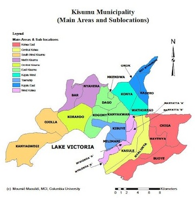
Present-day Kisumu consists of 25 sub-locations that can be grouped into 10 main locations (Township, East Kolwa, Central Kolwa, SouthWest Kisumu, North Kisumu, Central Kisumu, East Kisumu, West Kajulu, East Kajulu, and West Kolwa). The city covers a total area of 417 sq. km, of which 297 km is land and 120 sq. km is water mass.

The above map shows the distribution of health facilities in Kisumu City. The facilities include hospitals, health centers, dispensaries, clinics and maternity and nursing homes. There are 62 registered health facilities in Kisumu East District, including three public hospitals, six public health centers and 21 public dispensaries. A 2012 survey conducted by MCI uncovered an additional 21 facilities which were not registered with the District Health Records Information Office (DHRIO).

The above map shows the distribution of pre-primary schools in Kisumu according to whether they are public or private. As it can be seen, there are more private ECD/pre-primary schools than public schools and they are concentrated in central part of the city while public schools are more spread out. Sub-locations that have the least number of ECD/pre-primary schools include Bar, Dago, Mkendwa, Oko and Kadero. Most of the pre-primary schools in slum areas like Manyatta are private.

The above map shows the distribution of primary schools in Kisumu. It is clear that there are many more public than private primary schools in Kisumu Municipality. Moreover, private primary schools are concentrated in the central part of the city whereas public primary schools are more evenly distributed. Sub-locations such as Dago in East Kisumu, Kasule in Central Kolwa and Got Nyabondo in Kajulu East have the fewest primary schools.

The above map shows the distribution of secondary schools in Kisumu. As can be seen, there are relatively few secondary schools, and private secondary schools are concentrated near the Central Business District while public schools are more evenly distributed.


